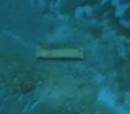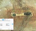


This underwater linear feature is located off the Florida coast and is approximately 27 feet in width. The line could be a ship track yet it’s not likely since it can be seen on the underwater landscape via Google Earth for over 10 years. Google Earth has a feature that allows users to visit an area over time. By dragging the historical imagery bar a viewer can go back in time within the Google Earth image database. This particular feature was present on the underwater landscape in 2004. This suggests we are seeing an ancient road or path that could lead to ancient settlement areas.
Taking a more aggressive calculation of a 3mm sea level rise estimate per year (based on NOAA current sea level rise data), this area would have been above water approximately 3,000 years ago. Taking a more conservative estimate of a 1mm sea level rise per year, this area would have been above water approximately 9,000 years ago based on an average depth in this area of 30 feet.
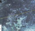
Image from 2004:

Underwater Line, Florida Coast
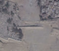
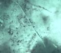
Image from 2014:

Underwater Line, Florida Coast 2